|
| Type of Climate
Charleston, South Carolina, has a Humid Subtropical Climate like most of the southeast. This is found on the east coast of continents between 20o and 40o North and South latitude. A humid subtropical climate is known for mild winters with hot and humid summer months. The humidity can make some summer days feel unbearable. Winters are very short and snow is extremely rare. [C1]
Precipitation Chart
 http://rssweather.com/climate/South%20Carolina/Charleston%20Ap http://rssweather.com/climate/South%20Carolina/Charleston%20Ap
|
Precipitation
As shown from the chart to the left, most of the precipitation told for Charleston, South Carolina, occurs during the summer months of June, July, August, and September. Over 41 percent of the year's average rain fall happens during the summer months. [C2] This is in correlation to the hot and humid summers of the Humid Subtropical Climate.
Most precipitation comes in the form of thunderstorms or showers with the exception of tropical storms. During the winter months, snow and flurries are very rare. The precipitation is more uniform in the winter. [C2]
The average amount of total precipitation for the year in Charleston, South Carolina is 51.4 inches. [C3]
Hurricanes
Charleston is a hotbed for tropical storm activity. On average, it is brushed by a hurricane every 4.42 years and is directly hit by a hurricane once every 11.42 years. Charleston was last affected by Tropical Storm Alberto in 2006. This tropical storm had wind gusts of 40+ miles per hour and caused some flooding to homes in the Charleston area. [C4] The video to the right is coverage from the National Weather Service on the subject of Hurricane Hugo. Hurricane Hugo was a major hurricane that hit Charleston in 1989.
|
|
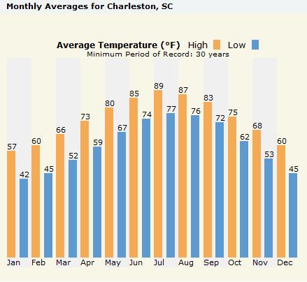
Temperatures
The average temperatures can be found on the chart below:

http://www.weather.com/weather/climatology/monthly/USSC0051
|
Degree Days
On average, there are 2,197 heating degree days in Charleston. Charleston also averages about 2,115 cooling degree days a year. [C5]
|
Current Weather

|
Topography
|
Situated along the Atlantic Ocean, Charleston sits at one of the lowest points in the state of South Carolina. Along the coastline the county of Charleston is framed by the Santee and Edisto Rivers. As it sits on the Atlantic Ocean Watershed, these two rivers along with the rest of the state’s streams flow eastward until it reaches the coast. The overall topographic grade of the state is illustrated by the image to the right.
As the image shows, the elevation decreases from northwest (highest point, Sassafras Mountain at 3,560 ft. high) to southeast (lowest point sea level). The Appalachian Mountains channel runoff to lower elevations. The decreasing elevation funnels precipitation towards the coast into tributaries and other bodies of water till it reaches the coast and empties into the Ocean. [T1]
|

http://geology.com/state-map/south-carolina.shtml
|
Land Use
| Being the second largest city in South Carolina, Charleston has a dominant urban population. 87% of people live in urban areas. 13% live in rural or agricultural areas. 453 acres are harvested for corn, 121 for wheat, 1618 acres for vegetables, and 365 acres are occupied by orchards [L1]. Although this area is very largely urban, they have many beautiful parks, lakes, and conservation areas. The city owns 90 parks, which encompass 1,200 acres of recreation areas and open space [L2]. |
 Plugin error: That plugin is not available. Plugin error: That plugin is not available.
|
Geographic Location
Charleston, SC is located on the southeast edge of South Carolina’s boundaries. As it borders the Atlantic Ocean, Charleston is an essential seaport to the East Coast. The port of Charleston is made up of five different terminals, and it is the second largest source of revenue for South Carolina, standing only behind tourism. The Cooper and Ashley Rivers merge at the port of Charleston, emptying into the Atlantic Ocean. These two rivers also contribute to the formation of many creeks and streams located inland in Charleston. Georgetown, another coastal region of South Carolina, is located about halfway down the Atlantic Coast of South Carolina and is the midpoint between Charleston and Myrtle Beach. [G1]
 
www.worldtimeserver.com/images/maps/US-SC.jpgimages/maps/US-SC.jpgimages/maps/US-SC.jpg http://wwp.greenwichmeantime.com/images/usa/south-carolina.jpg
Ecology
Charleston, South Carolina is the perfect location to find a mixture of biota within the United States. The city itself is a Metropolitan Area, but the surrounding areas constitute a wider variety of biota. For instance the state of South Carolina is in a biome that is referred to as a temperate deciduous forest. To be biota. For instance the state of South Carolina is in a biome that is referred to as a temperate deciduous forest. To be  more specific Charleston is located in a division of this temperate forest known as outer coastal plain mixed province [E1]. Parts of South Carolina, including areas near Charleston are part of the southern mixed forest province. This means that these biomes have a mixture of temperate deciduous and temperate rainforest vegetation commonly located in the Southeastern part of the United States [E2]. more specific Charleston is located in a division of this temperate forest known as outer coastal plain mixed province [E1]. Parts of South Carolina, including areas near Charleston are part of the southern mixed forest province. This means that these biomes have a mixture of temperate deciduous and temperate rainforest vegetation commonly located in the Southeastern part of the United States [E2].
Vegetation in these areas includes a large variety of trees, bushes, shrubs and flowers. These include evergreen oaks, bay laurels and tulip trees. Some of the more abundant species of vegetation in these areas include lianas, epiphytes and mosses [E3]. Other types of vegetation found in these areas include broadleaf deciduous trees like oak, hickory and maple tree as well as needle leaf evergreen trees such as the loblolly and shortleaf pines [E4]. Grasses include bluestem
Outer Coastal Plain Mixed Province and bushes include dogwood and viburnum [E5].
Fauna in Charleston include a variety of small mammals often found in all parts of the United States. These include: squirrels, raccoons, rabbits, opossums, moles and foxes. The white-tailed deer is the only large mammal found in this area. Bobwhite quails, wild turkeys, Carolina wrens and red-cockaded woodpeckers are the main feathered inhabitants of this region, as well as many migratory birds and waterfowl [E6]. The
American alligator is the largest of the variety of reptiles, which also include: copperhead snakes, glass lizards and salamanders, which live in the coastal plain mixed province [E7].
Economic Provinces with Charleston highlighted
Charleston is located on the coast of South Carolina where freshwater rivers and streams intermix with saltwater from the Atlantic Ocean to create estuaries. Flora in these ecosystems include algae, seaweed, cypress trees, gum trees and grasses, and fauna includes varieties of worms, oysters, crabs and waterfowl [E8].
Other biomes that can be found in the Charleston area include wetlands, tidal streams, marshes, swamps, lakes and sporadic coniferous forests.


Viburnum Carolina Wren View of wetlands south of Charleston Southern Mixed Forest Province
Economy & Industry
With Charleston's prime location on the Atlantic Ocean, it has become one the United States leading port cities. The Port of Charleston which has five terminals, three located on the city harbor and located in the Cooper River system, which collectively move roughly one million shipping containers through the port each year, has become one of the busiest ports in the southeast (4th in the nation) [EC1] [EC2]. Port Authorities announced the Port handles nearly $3 million in cargo every hour and offers service to more than 140 countries across the globe [EC2]. According the Charleston Regional Development Alliance (CRDA), the Port of Charleston is the most productive container port in the United States, providing companies access to all twenty of the carriers in the container trade business [EC1]. Due to the grand scale of the Port, it is not shocking to find that port activities account for a large portion of the city's revenue, second only to tourism.
Due to the significance of Charleston's involvement in import-export trading on a national scale it comes as no surprise that the security industry continues to grow rapidly in the area. This need for greater security and knowledge about the containers coming and leaving the port has lead to development of companies such as Navigational Sciences, who help to wirelessly track shipping containers throughout their journey. In addition to private security ventures, Charleston also has a strong government presence ranging from branches of the military such as Coast Guard, Navy, Army, and Air Force to involvement of agencies such as the Department of Defense and Homeland security. Although, the naval base at Charleston is no longer operational many naval personal still remain working in the area [EC1].
The CRDA has also cited the aerospace/aviation field of industry to be experiencing economic growth within the area. The growth in the field is largely assisted by Boeing's decisions to have a large amount of their new 787 Dreamliner passenger jet to be assembled in Charleston. [EC1] In order to fulfill such a great requirement companies such as Vought Aircraft Industries have merged with Alenia North America to form Global Aeronautica. In addition, the Air Force has also established the Charleston Air Force base which is home to the 437th Airlift Wing. The 437th involves four operational groups that consist of 21 squadrons [EC3].
Other recognizable industries in the area include the automotive industry, which includes major industry leader Daimler of the Daimler-Chrysler group, and biosciences consisting of multiple pharmaceutical and nanotechnologies companies [EC1].
  
Port of Charleston loading crane Boeing 787 Dreamliner Port of Charleston
Transportation

Two interstates serve Charleston, SC. The city is bisected by interstate I-26, and is encircled by I-526. I-526 is also known as the Mark Clark Expressway [TR1]. Charleston also has the Charleston International Airport. The Charleston International airport is located in North Charleston just off of I-26. The airport also serves as a United States Air Force Base through a joint use agreement. In 2006, there were 943,305 passengers who flew out of the airport. Charleston International Airport has two runways, one is a main instrument runway which is 9,000 feet long and 200 feet wide, the other is a crosswind runway which is 7,000 feet long and 150 feet wide [TR2].
Image: http://www.sciway.net/maps/charleston-sc-map.gif
The Arthur Ravenel, Jr. Bridge

Image source: wikimedia.org
In 2005, Arthur Ravenel, Jr. Bridge was opened and is considered the largest cable-stayed bridge in the US. It connects Mount Pleasent with downtown Charleston by crossing the Copper River. It has over eight lanes for cars and a 12 foot lane for pedestrians. Its new sleek design enables traffic to travel over the bridge quickly and effectively. It was build to withstand many natural disasters including hurricanes with winds up to 300 mph and earthquakes up to approximately 7.4 on the Richter scale. [TR3]
Interesting Facts

- The NCCOS’s Center for Environmental Health and Biomolecular Research is located in Charleston where they use field and laboratory studies to describe, evaluate, and predict the controlling factors and outcomes of natural and anthropogenic influences on coastal resources [IF1]
- The land area of South Carolina in 2000 was 30,109.47 square miles, the land area of Charleston is 97 square miles. [IF2]
- In 1886, the city had to be rebuilt because of an earthquake that ranked 7.5 on the Richter Scale. [IF3]
- Charleston has an active port. [IF4]
- Charleston is the location of a National Monument, Fort Sumter, a fort used in the Civil War. It can be seen on the right. [IF5]
- Charleston is home to an enormous Waterfront Park that spans 1000 feet down the harbor. [IF6]
- Charleston has two islands located less than 30 miles away, Seabrook and Kiawah [IF7]
http://fentonhistorycenter.org/civilwar/images/sumter.jpg
City References
[P1] http://www.census.gov/
[P2] http://www.city-data.com/city/Charleston-South-Carolina.html
[C1] http://www.uwsp.edu/geo/faculty/ritter/geog101/textbook/climate_systems/humid_subtropical.html
[C2] http://www4.ncdc.noaa.gov/cgi-win/wwcgi.dll?wwDIStnSrch~StnID~20017349
[C3] http://www.dreamcharleston.com/charleston-weather.html
[C4] http://www.hurricanecity.com/city/charleston.htm
[C5] http://www.homeinsight.com/home-value/SC/charleston.asp
[T1] http://geology.com/state-map/south-carolina.shtml
[G1] http://en.wikipedia.org/wiki/Charleston_south_carolina
[L1] http://www.city-data.com/county/Charleston_County-SC.html
[L2] http://www.charlestoncity.info/dept/content.aspx?nid=202&cid=834
[E1] http://www.fs.fed.us/colorimagemap/ecoreg1_provinces.html
[E2] http://www.fs.fed.us/colormap/ecoreg1_provinces.conf?663,365
[E3] http://www.fs.fed.us/colormap/ecoreg1_provinces.conf?663,365
[E4] http://www.fs.fed.us/colormap/ecoreg1_provinces.conf?632,346
[E5] http://www.fs.fed.us/colormap/ecoreg1_provinces.conf?632,346
[E6] http://www.fs.fed.us/colormap/ecoreg1_provinces.conf?663,365
[E7] http://www.fs.fed.us/colormap/ecoreg1_provinces.conf?663,366
[EC1] http://www.crda.org
[EC2] http://www.port-of-charleston.com/
[EC3] http://www.charleston.af.mil/
[TR1] http://www.sciway.net/maps/charleston-sc-map.gif
[TR2] http://www.chs-airport.com/facilities.htm
[TR3] http://en.wikipedia.org/wiki/Arthur_Ravenel,_Jr._Bridge
[IF1] www.noaanews.noaa.gov/stories/archive.htm
[IF2] http://www.census.gov
[IF3] http://www.nps.gov/history/nr/travel/Charleston
[IF4] http://www.port-of-charleston.com/   
[IF5] http://www.nps.gov/fosu
[IF6] www.homeandabroad.com/c/104/104_Charleston_visit_guide.html
[IF7] www.seabrookisland-kiawah-realestate.com/cityprofile.htm
Weather Profile

Tropical Cyclones (Tony Petruzello)
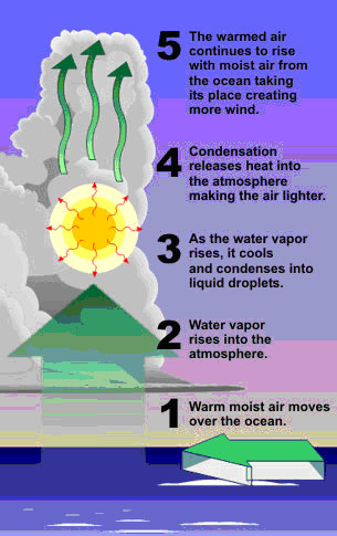
Tropical cyclones, known as hurricanes in the region of Charleston, South Carolina, are the most destructive storms on earth and have crushed the city of Charleston on numerous occasions. The position of Charleston along the coast of the Atlantic Ocean makes it a prime location for tropical cyclone activity. The most recent and to many, the most notable of these disasters was Hurricane Hugo in 1989. Hurricane Hugo hit Charleston with 135 mph winds and a storm surge of 5 feet. Considered to be one of the most destructive hurricanes in recent memory, Hugo caused over $10 billion in damages making it one of the most costly tropical cyclones in United States history [HH3].
An average year sees 12 tropical cyclones develop in the Atlantic Basin [HH4], about 10 of which become named systems. In order for a tropical cyclone to form in the Atlantic Basin a few conditions must be present. The first of which is warm ocean water temperatures. Tropical cyclones are fueled by heat, therefore the ocean waters must be at least 27o C. Another necessary condition is an unstable atmosphere. Most often it is through thunderstorms that the heat being stored in the ocean can be used to fuel the development of a tropical cyclone. Conveniently, an unstable atmosphere is a necessary element for thunderstorms to occur as well. Other conditions that must be met include a mostly moist troposphere, a minimum distance of 500 km from the equator, and an already existing disturbance near the surface.
While hurricanes are quite commonplace in the Atlantic Basin, Hurricane Hugo was the first hurricane in a thiry year span to hit Charleston directly. However, the effects of a hurricane can be quite devastating. As late as 1999 residents of Charleston were still rebuilding the city from Hugo in 1989. Flooding plays a major role in the amount of damage that is done in a hurricane as well as the wind. A category 1 hurricane carries winds of 74-95 mph while a category 5 hurricane has wind speeds of 155 mph or more [HH3]. These winds can take down trees and power lines as well as move houses off their existing foundations.
Photo Source
Case Study - Hurricane Hugo (Brie Bauer, Tony Petruzzello, Erin Leitschuh)

Hurricane Hugo occurred on September 22, 1989. It was a category four hurricane, and became the most intense cyclone to hit the coast of the United States north of Florida. It
had the lowest pressure (936.5 mb), strongest winds (140 mph), and highest tidal surge (19.8 feet above sea level). As seen on the map below, Hurricane Hugo first made landfall on the islands of Guadeloupe and Montserrat. It then continued north to the coast of South Carolina [HH1] . After this, it moved inland and made its way up through the northeast. The storm was first detected on September 9th when a group of thunderstorms moved off the coast of Africa. Hugo first became a tropical storm on the 11th of September and was declared a hurricane on the 13th [HH2]. In preparation for Hugo, hurricane warnings were issued and 250,000 people were evacuated from Georgia, South Carolina, and North Carolina.
Photo Source -->

Celsius. Hurricanes also require a deep layer of warm water, and a weak wind shear. Hugo occurred in late September, as hurricane conditions are favorable aft
er summer, when water temperatures rise. It is typical for tropical storms and hurricanes to occur in the Atlantic basin, but this was the first hurricane to hit the coast of South Carolina since Hurricane Gracie 1959 [HH1] .
Lucky for the residents of Charleston, most of Hugo’s destruction occurred over the Frances Marion National Forest, a sparsely populated area of South Carolina. According to the USDA Forest Service Hugo destroyed at least $100 million worth of timber as the forest was completely destroyed. Most of the homes and businesses along the coast were destroyed as homes were literally knocked off their foundations. According to one source, at the Dunes marina more than 100 boats were stacked in a pile that ended up being more than 50 feet tall [HH1]. Flooding was also significant as more than 80% of the historic buildings in Charleston were damaged. When the costs of the damages were totaled, Hugo ended up being the second most costly hurricane in the history of the United States, trailing only Hurricane Andrew in 1992 [HH3].
<-- Photo Source
Although residents of South Carolina were told to evacuate, Hugo was responsible for the deaths of 20 people in South Carolina, 35 in the United States, and 76 overall. 56,000 people were still homeless one week after the storm and 24 counties in South Carolina were declared to be Federal Disaster Areas [HH1].
Lightning(Kelly Fahy-kfahy2)
Lightning Occurances from: 1959-1994 [L3]
| State |
Fatalities |
Injuries |
Casualties |
Damage reports |
| South Carolina |
77 |
229 |
306 |
717 |

Lightning occurs quite frequently in Charleston, SC and along the Southern Atlantic Coast. In a study from 1989-1998 Charleston had around 5 strikes of lighting per kilometer squared every year. [L1] The peak months for lightning strikes are the summer months from June-August. It is during this time that the lower atmosphere is the most conducive to lighting because the air is very moist and warm due to the breezes produce
d by high sea surface temperatures. [L2] http://www.panbo.com/archives/2006_10.html
Lightning forms from two very important things. The first is interface charging. Interface charging occurs when ice crystals pass their electrons to larger particles such as hailstones. This causes the large falling particle to maintain the negative charge and the ice crystals to maintain their positive charge. While the interface charging continues the induction charging can play a part in accelerating the process. Interface charging occurs when the falling hailstones collide with the rising ice crystals and they transfer their charges and an electric field forms. The more the collisions occur the more the charge increases until eventually lightning occurs. This process continues through the entire storm. [L2]
<-- Photo Source
Forecasting lightning is often difficult anywhere that you live. We can predict the times that they will occur because we know they develop in thunderstorms, but it is impossible to forecast exactly where they will occur because they are very random, frequent, and widespread. [L2]
From 1959-1994, South Carolina State had about 306 deaths and injuries due to lightning. This is the 16th highest number for all 50 states. [L3] One explanation for the injuries being so high in Southern States is that a lot of people are involved in outdoor activities such as golfing, boating and going to the beach. All of these activities automatically
increase your chances of being struck. [L5]
http://www.nssl.noaa.gov/primer/lightning/ltg_climatology.html

Case Study - Lightning
(Kelly Fahy-kfahy2, Beth Leabru-eleabru2, Mike Flood, mflood2)
Michael Jurist, 22, of Hilton Head Island was killed on July 31, 2007 around 5:20. This city is located about 35 miles South of Charleston South Carolina. Michael and his mother were taking a walk along Hilton Head Beach when thunderstorm conditions started to develop. The National Weather Serves had issued a storm warning for the entire Southern Coast earlier that day.
Instead of seeking shelter they continued their walk until conditions started to worsen. It was then that Michael was struck by lightning. After getting help, Medics tried to revive him without luck. Doctor’s claimed that Michael’s death was caused because of the lightning strike. His mother was also showing lightning like conditions: “memory loss, attention deficits, sleep disorders, numbness, dizziness, and weakness are some of the maladies cited,” but they were much less severe. [L4] [L7]
Since lightning is so inconsistent, Michael did not expect he was going to be hit by lightning. However, walking along an open beach during a thunderstorm did not help his odds. Since the storm was well forecasted he should have followed the safety precautions set by the NWS and taken shelter in facilities provided at one of the beach access points located on Hilton Head Beach, Fish Hall Creek Park would have been a possible safe area (location of restroom facilities) for Michael [L6].

In my opinion Michael being struck occurred because the negatively charged electrons in lighting tends to hit the highest point of contact with the positive electrons from the surface, thus causing lightning to try and find the shortest path. Since this occurred on a beach, Michael was the highest point of contact in relation to the surface. He was not surrounded by trees or building that could have prevented the bolt to veer in a different direction. As a result, Michael was struck by lightning. Since the human body is not prepared for the type of charge that the bolt releases he was essentially electrocuted.
Unfortunately this happens to many people every year. Lightning goes hand in hand with thunderstorms, so people need to make them selves aware of safety precautions that should be taken in the times of thunderstorms and lightning. Even after hearing Michaels story events like his continue to occur in the surrounding area which means that people are not taking deaths such as his seriously. Simple precautions include finding shelter in a beach access point or pavilion, or an even better solution would have been if he took refuge in his car, “inside a car with a metal roof” [L5].
Carl Fogg of the Charleston Harbor during a storm.
If this sort of shelter is not available the best precaution to take is to stay away from isolated trees because lightning tends to strike the tallest object. Also stay away from large clearings because it is possible that the tallest object in the clearing would be a person. The best place to stand when no shelter is available is beneath a small group of trees that borders on a group of larger, taller trees [L5]. Had Michael known about the storm warning, or took the proper steps it is very possible he would still be alive today.

Blizzards (Mike Flood, mflood2)
Blizzards are some of the most destructive storms and disturbing storms facing citizens of the United States. Blizzards are defined as blinding snowstorms, which possess winds between 35 to 58 miles per hour, and temperatures of 20 degrees Fahrenheit and negative 30 degrees Fahrenheit [B1].
A blizzard is considered severe when there is a temperature at of below ten degrees Fahrenheit, winds greater than 45 mph, and visibility near zero [B2]. Blizzard formation requires three different ingredients; bitterly cold air, wind, and snow. The cold air is supplied by the plains of Canada, this cold air creates high pressure at the surface. High pressure is critical because it increases the pressure gradients magnitude when the system reaches the U.S. as it comes down from Canada. The artic front which makes its way down from Canada then collides with an extratropical cyclone, which provides the final two ingredients of the storm, wind and snow. Blizzards can form within the circulation of both Colorado Cyclones and Alberta Clippers [B1].
A blizzard has not impacted Charleston, SC. Blizzards do not occur in Charleston because the air is never cold enough to sustain blizzard conditions. There are no Blizzards on record since 1959 [B1]. However, Charleston does occasionally receive snows. In 2006 Charleston received the earliest snows on record. With between a light dusting and an inch of snow falling in the city on November 21st. The snow was due to what the National Weather Service deemed as a “major and highly unusual coastal storm.”
Picture: Snows from November 21, 2006 in Charleston. -->
Flooding (Beth Leabru, eleabru2)
Flooding is one of the most common hazards in the United States. This national hazard affects a wide range of communities, from local neighborhoods to large river basins covering multiple states. Furthermore, not all floods are alike; “flash floods can develop quickly, sometimes in just a few minutes and without any visible signs of rain.” Flash floods have the power to sweep away anything in there path, carrying rocks, mud, and other debris to create a dangerous wall of destructive water. An alternate method of flooding is overland flooding. This type of flood “occurs outside a defined river or stream, such as when a levee is breached, but still can be destructive. Flooding can also occur when a dam breaks, producing effects similar to flash floods.” These floods overflow the river shoreline and invade upon the surrounding property, causing extensive damage. [F1]
Charleston, South Carolina is at risk for flooding in multiple ways. Situated along the Atlantic coast it is susceptible to flash flooding from storm surges as well as inland flooding from the numerous rivers that surround the area. Flooding is not designated to one season; “some floods are seasonal, when winter or spring rains combine with melting snows and fill rivers with too much water too quickly. Other floods are associated with land-falling hurricanes and tropical storms in the summer and fall” [F3]. Charleston is sitting in a major pathway of typical hurricane movement, starting with the Coriolis force causing the hurricane to drift westward and poleward, and then the westerly winds push it back east to the north of the high pressure center, potentially in Charleston’s direction. [F7] Hurricane Hugo was the worst hurricane to hit Charleston since 1752, it was about a category 3 when it hit land and produced tides 12 to 17 feet above normal. [F8]. Storm surges from hurricanes can cause extensive damage to coastal territories while the inland rivers, Ashley River, Copper River, Wando River, can flood due to extensive rains from stationary fronts or runoff from melting snow in the mountains.
<-- Photo Source
In the last 12 years South Carolina has spent more than $7 billion on damages that occurred from flooding and hurricane events; and future floodplain development will increase the number of properties/citizens at risk to flood damage. The South Carolina Department of Natural Resources (SC DNR) is on a mission to work with South Carolina citizens and communities to minimize losses due to flood conditions [F4]. The state of South Carolina has enacted a tough statewide building code and a comprehensive-planning
requirement for localities. These building codes are important in protecting the citizens as well as the property of the city [F5]. Moreover, gauges have been put in place to measure river levels and water output so quick and accurate warnings can alert communities when risk of flooding is predicted. [F6]

Tornadoes (Mike Hawrysio - mhawrys2)
Although tornadoes can hit anywhere at anytime, the United States marks the spot of where about seventy-five percent of tornadoes actually strike [F7]. As tornadoes form from supercell thunderstorms, and these thunderstorms can be formed almost anywhere in the world, Charleston, SC isn’t exactly more or less prone to being hit by a tornado than other parts of the world. However, the middle latitudes of the earth (30-50 degrees) contain a region in which cold, polar air meets warm, subtropical air, providing favorable conditions that create wind shear and promote rotation of a storm cell [TT2].
South Carolina currently holds an average tornado occurrence of fourteen tornadoes per year. Tornadoes in South Carolina, and the rest of the U.S., are most frequently experienced during the spring and early summer, as many thunderstorms occur during this season.
Although Charleston, South Carolina doesn’t either promote or demote tornado formation, this state experienced 18 tornadoes in the year 1984. Fifteen recorded fatalities and over 400 injuries make this year one of the worst for tornadoes in South Carolina. Also, adjusted for today’s inflation, the estimated damage received that year from tornadoes alone reached about $124 million [TT3].
Photo Source -->
Tornadoes are common anywhere in the world and at almost any time. There has been at least one tornado recorded in every state of the U.S. Although Charleston, SC doesn’t have any unique characteristics to promote tornado formation, the 14-tornadoes-per year average is still something to be cautious of.
Thunderstorms
Ryan Godke-rgodke2
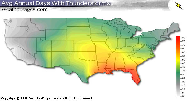
Ranked 24th as the most likely city to receive thunderstorms annually, Charleston, South Carolina typically experiences 58 days a year with thunderstorms. In comparison Fort Myers, Florida is ranked 1st with 89 days of thunderstorms and Peoria, Illinois is ranked 48th with only 50 days annually. Furthermore, Charleston is ranked 33rd in the nation for amount of precipitation annually with 51.53 inches, which typically results from thunderstorms and hurricanes on the East Coast. [TS1].
Photo Source -->
Although most thunderstorms in Charleston occur during the summer months, the most severe thunderstorms that affect Charleston are associated with squall lines and cold fronts occurring during the late winter or early spring. [TS2]. Since Charleston is a costal city, it is also affected by severe thunderstorms and tropical storms that develop in the Atlantic Ocean. These thunderstorms typically hit Charleston in the summer months with August producing the most occurrences. [TS2]. These severe thunderstorms have also produced 0.5 to 1.5 days with hail and about 11 tornadoes per year. [TS2].

Due to the fact that the majority of severe thunderstorms that affect Charleston develop on squall lines and cold fronts, most of them originate as frontal squall thunderstorms that develop in the Midwest and travel to the east coast. Four conditions must be achieved in order for these thunderstorms to develop. These four conditions are: “a moisture source, an unstable environment, an updraft triggering mechanism and a vertical wind shear.” [TS3]. Forming at the tail of an extratropical cyclone, these storms develop when hot, moist air accumulates in front of cold fronts or upper level fronts. [TS3]. These thunderstorms are very similar in structure as Mesoscale Convective Systems with an anvil shape and warm air lifting in the convective region creating an overshooting top. With the addition of cold, dry air descending as it reaches the convective region, this type of thunderstorm is capable of producing all intensities of rain from light to moderate to heavy. [TS3]. Although squall line thunderstorms are the most common for Charleston, Mesoscale Convective Systems, supercells and tropical storms are also likely to occur in this area too.
<-- Storm traveling off the coast of Charleston. Courtesy: Steve Casey
According to the NOAA Satellite and Information Service, only one person has died in a thunderstorm that occurred in Charleston. This was the result of strong winds knocking down a tree onto a vehicle. This occurred on July 13, 2004. [TS4]. Furthermore, the most damage ever caused by a thunderstorm that occurred in Charleston was on August 11, 2000 when several large shipping containers were deposited into the Atlantic Ocean causing $200,000 worth of damage. [TS4]. The record wind speed for one storm in Charleston was 71 knots on May 9, 1997. This resulted in three aircrafts being flipped over at a local airport. [TS4]. The most recent severe thunderstorms to affect the Charleston area happened on March 4, 2008. During this day most of South Carolina, including Charleston, experienced severe wind damage and electricity blackouts. [TS5].
El Nino

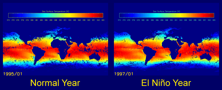
Last year in Charleston, El Nino played an important role in breaking up several potential tropical storms because the warming trend in the Pacific Ocean increased the wind shear which destroyed the storm. This year, meteorologists think El Nino is very unlikely to pop up; however, it was unexpected last year as well. [N1] El Nino is a warm ocean current that usually develops off the western coast of Ecuador and Peru and can sometimes lead to unusual weather events globally. El Nino usually occurs every 4-12 years and happens when the normal pattern of the tropical Pacific pressure weakens. [N2] This weakening leads surface pressure systems to weaken in the Pacific Ocean, trade winds to weaken, stop, or reverse, water in the eastern Pacific to warm, and precipitation to shift eastward. In Charleston it has the effect of creating high altitude wind shears that sometimes cause hurricanes to be destroyed. The destruction of these storms can lead to severe droughts however. El Nino also has the effect of redistributing precipitation which again leads to droughts; similar to the one Charleston just experienced this past fall and winter, and sometimes leads to flooding. [N3]
Erin Leitschuh-eleitsc2
http://www.atsr.rl.ac.uk/images/asst/elnino/El_nino_Animation.gif
Drought
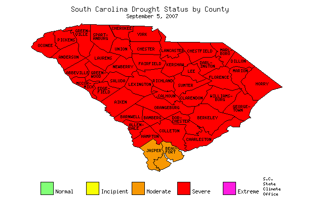
While not a yearly occurrence in the South Carolina and Charleston area, droughts tend occur with some frequency within the region. The length and intensity of the regional droughts can vary greatly ranging from a seasonal drought conditions to severe drought conditions that can persist for several years. The most recent drought  to impact the South Carolina area started in the Spring of 2007 and is predicted to continue on into 2008 although many counties have received a reduction in the severity status of the drought. to impact the South Carolina area started in the Spring of 2007 and is predicted to continue on into 2008 although many counties have received a reduction in the severity status of the drought.
<-- Photo Source
Droughts in the Carolinas and in fact much of the southeastern United States are often the result of the same combination of conditions. The major meteorological event that contributes to drought throughout the region is the presences of La Nina weather patterns. La Nina, the opposite of El Nino, is the average cooling of the surface temperatures in the central and east central areas of the Pacific Ocean. La Nina weather will cause the subtroical and polar jetstreams to meet at a more northernly latittude than on a standard year.[D1] As seen in the figure to the right, the area where the two jetstreams merge causes warm moist air fronts to mix with fronts consisting of cold dry air creating percipitation in the northern portion of the US while leaving the southern portion drier than normal. The other major meteorological contribution to droughts in the region is stationary high pressure systems. When high pressures over the surface and aloft persist a very stable atmosphere is created resulting in a lack of cloud formation and thus a lack of rain. In fact, according to the National Oceanic and Atmospheric Administration (NOAA) is was consistent high pressure systems hovering over the southeast that caused 3 months of drought for South Carolina in the Spring of 2007.[D2] created resulting in a lack of cloud formation and thus a lack of rain. In fact, according to the National Oceanic and Atmospheric Administration (NOAA) is was consistent high pressure systems hovering over the southeast that caused 3 months of drought for South Carolina in the Spring of 2007.[D2]
Photo Source -->

Although, droughts do not display the destructive forces often associated with weather such as tornadoes, hurricanes, and thunderstorms, they are none the less an extremely devastating weather event. One of the most notable effects of droughts on the region is the destruction of the livelihood of the agricultural industry. With no precipitation to water their crops farmers must resort to purchasing water or losing their crops. However, even this is problematic when long droughts have caused wells and aquifers to run dry and reservoirs to be near depleted of their water. Unfortunately, all the residents can do is sit by and watch as lake levels drop further and streams are reduced to trickles while waiting on the much anticipated rain.[D3] Luckily, for Charleston, the drought mainly affects the inland water levels and the booming trade industry entering through its ocean ports does not feel the full effects of the drought.
Photo Source
Matthew Widtmann-mwidtma2
Case Study - Drought
 The residents of South Carolina had seen and lived through droughts in their time, however, in the start of 1998 its unlikely that any of them could have foreseen the coming of the worst drought in the state's recorded history. By the summer of 1998 it was clear that the drought was in full effect and not likely to end any time soon. It is unlikely though, that any one could have predicted that the drought would persist to plague the area, causing billions of dollars in damage, before finally coming to end a record 4 years later in 2002. According the U.S. Water News, some states were as much as 59 inches below the normal level of precipitation from the start of 1998 to Janurary of 2002, while Charleston experienced a value of 22 inches below normal during the same time period.[D3] Once the damages had been assessed it was calculated that the forestry industry had been dealt a 1.3 billion dollar blow itself, while the power generating industry sustained an estimated 38 million, and other industries averaged $500,000 in losses. The drought was also devastated the agricultural industry so heavily that S.C. State Climatologist Hope Mizzell believes it will take at least five years for the industry to recover. Due to the extended nature of droughts these numbers may even be on the low side based on the difficulty of estimating damages to tourism and industries such as freshwater fisheries, The residents of South Carolina had seen and lived through droughts in their time, however, in the start of 1998 its unlikely that any of them could have foreseen the coming of the worst drought in the state's recorded history. By the summer of 1998 it was clear that the drought was in full effect and not likely to end any time soon. It is unlikely though, that any one could have predicted that the drought would persist to plague the area, causing billions of dollars in damage, before finally coming to end a record 4 years later in 2002. According the U.S. Water News, some states were as much as 59 inches below the normal level of precipitation from the start of 1998 to Janurary of 2002, while Charleston experienced a value of 22 inches below normal during the same time period.[D3] Once the damages had been assessed it was calculated that the forestry industry had been dealt a 1.3 billion dollar blow itself, while the power generating industry sustained an estimated 38 million, and other industries averaged $500,000 in losses. The drought was also devastated the agricultural industry so heavily that S.C. State Climatologist Hope Mizzell believes it will take at least five years for the industry to recover. Due to the extended nature of droughts these numbers may even be on the low side based on the difficulty of estimating damages to tourism and industries such as freshwater fisheries, which the Department of Natural Resources (DNR) says the average out of state angler spends nearly $700 a year on.[D4] which the Department of Natural Resources (DNR) says the average out of state angler spends nearly $700 a year on.[D4]
<-- Photo Source
The severity and length of this specific drought was based on a unique combination of multiple La Nina years in combination with the effects of the Bermuda High. The Bermuda High is a constant strong high pressure system that pushes up into the southeastern portion of the United States. In the years of the drought the high pressure systems resulting from the Bermuda High were stagnant over the South Carolina region leading to little cloud formation which resulted in increased temperatures and decreased rainfall during spring, summer, and fall seasons. In addition to creating a stable atmosphere, the resulting high temperatures also resulted in the quick evaporation of what little rainfall was received. To compact upon the drought conditions caused by the Bermuda High during these season, the years of 1998-99 and 2000-01 were considered La Nina years.[D5] Since La Nina causes the subtropical jetstream to shift northward, the moist air coming from the Pacific Ocean also shifts northward leaving the southern US drier than normal during the winter season. Another, smaller cause of the drought conditions seen during these years was that evaporation was unable to occur on a large scale in the State due to the fact that the soil had become so dry there was little remaining moisture.
Matthew Widtmann-mwidtma2
Ryan Godke-rgodke2
Photo Source
Image Source: http://www.nws.noaa.gov/os/heat/index.shtml
Heat Waves

Brent Kerby ---- bkerby2
Charleston, South Carolina has its share of dangerous hot temperatures and heat waves only add to the harm. The average temperature in the month of July is 89 degrees Fahrenheit with it only cooling off to about 77 degrees Fahrenheit. [HW1] With these high temperatures and very high relative humidity, a heat wave is just around the corner. Heat waves are mostly frequent in the summer months such as June, July, and August. Charleston’s last heat wave was in August of 2007 where one resident stated that the town felt like an oven. [HW2]
The term heat wave is not globally defined, but it is geographically defined. For simplicity, heat waves can be thought of as a long time with above average temperatures that make dangerous conditions for humans. Temperature itself is not the only factor that causes a heat wave. Relative humidity, radiant energy, and wind speed all help create a heat wave. The measure of these factors is called the apparent temperature which is equivalent to the Heat Index.
Heat waves can form when the jet stream goes extremely north pushing the polar mass up and allowing warm, moist air come in from the south. Another reason for Heat Waves is the Urban Heat Island Effect. This is one of the primary causes for the heat waves in Charleston. The Urban Heat Island Effect is caused by the loss of grass, trees, and other greenery to blacktop which stores more heat than the greenery. Also, with thousands of cars driving on this blacktop day and night, the heat cannot escape causing night temperatures to barely drop from the daily high temperatures. In a report from the EPA, it stated that Charleston’s “city temperatures in late summer afternoons are on average 5 degrees Fahrenheit higher than in the adjacent countryside.” This is due to the Urban Heat Island Effect. Charelston's Heat Waves will only get worse unless they fix their Urban Heat Island Effect problem. [HW3]
Heat waves kill the most people out of all weather related disasters. With coupled with a drought, heat waves can be even more dangerous. The Charleston County government has its own webpage on Heat Waves and states, “Heat kills by pushing the human body beyond its limits. Under normal conditions, the body’s internal thermostat produces perspiration that evaporates and cools the body. However, in extreme heat and high humidity, evaporation is slowed and the body must work extra hard to maintain a normal temperature.” [HW4] The website goes on to give many tips on how to stay safe in Charleston during a heat wave.

Hail (Brie Bauer)
Photo Source -->
Every year in the United States, hail causes 1-1.5 billion dollars worth of damage to crops and other property such as roofs, cars, airplanes, and homes. It can vary in size, with significant reports consisting of hail larger than .75 inches. [H2]
The hail that occurs in the Charleston, South Carolina region occurs most frequently during April, May, and June. This coincides with the peak thunderstorm season, as hail forms in these systems. Charleston averages about 27 days of hail per year, with and average of 67 significant reports of hail each year.[H1]

In order for hail to form, a thunderstorm must be present. Hail falls predominately in the perimeter of the updraft. These storms must have very strong updrafts. Hail develops in two stages- a hail embryo to a hailstone. Essentially, cloud droplets are taken upwards by the updraft, and are super cooled during their ascent. The longer the water droplet stays in the updraft, the more time it has to gain more particles and grow larger. Finally, when the particle become too heavy to stay in the updraft, it falls to the ground as hail!
The "Lowcountry" region of Charleston experiences many cases of hailstorms. For instance, Saturday March 15th was the day of a storm that caused 15 million dollars of damage across South Carolina, including hail damage to roofs, trees, and cars. One of the largest problem caused by hail in this area, is due to the smaller sizes of hail, damage might not be noticed after the storm. "These kinds of catastrophes have a long life," Bruce White said. "Not everyone may notice hail damage at first." Bruce White is a representative for State Farm insurance in the Charleston area. [H3]
Weather References
[D1] http://www.ocs.orst.edu/reports/enso_pnw.html
[D2] http://www.erh.noaa.gov/chs/text/PNSCHS_06012007.txt
[D3] http://www.uswaternews.com/archives/arcsupply/2soucar1.html
[D4] http://mooreschool.sc.edu/moore/research/Publications/BandE/bande53/53n1/droughts.html
[D5] http://ggweather.com/enso/years.htm
[HH1] http://www.geocities.com/hurricanene/hurricanehugo.html
[HH2] http://www.hpc.ncep.noaa.gov/tropical/rain/hugo1989.html
[HH3] Rauber, Robert, John Walsh and Donna Charlevoix. Severe & Hazardous Weather. 2nd ed. Dubuque, Iowa: Kendall/Hunt Publishing Company, 2005.
[HH4] http://www.usatoday.com/weather/hurricane/tropical-cyclone-basins.htm
[HH5] http://www.aoml.noaa.gov/hrd/Landsea/climvari/index.html
[L1] Rauber, Robert, John Walsh and Donna Charlevoix. Severe & Hazardous Weather. 2nd ed. Dubuque, Iowa: Kendall/Hunt Publishing Company, 2005.
[L2] http://www.nssl.noaa.gov
[L3] http://www.nssl.noaa.gov/papers/techmemos/NWS-SR-193/techmemo-sr193-3.html#section3
[L4] http://www.esdjournal.com/articles/Lightning/schhkilled.htm
[L5] http://news.nationalgeographic.com/news/2003/05/0522_030522_lightning.html
[L6] http://www.hiltonheadisland.com/beach.htm
[L7] http://www.lightningsaftey.noaa.gov/
[N1] www.charleston.net/news/2008/mar/03/researchers_gather_hurricane_conference32494/
[N2] Rauber, Robert, John Walsh and Donna Charlevoix. Severe & Hazardous Weather. 2nd ed. Dubuque, Iowa: Kendall/Hunt Publishing Company, 2005.
[N3] http://www.charleston.net/news/2007/may/23/get_ready_forecasters_predict_an_active_season/
[B1] Rauber, Robert, John Walsh and Donna Charlevoix. Severe & Hazardous Weather. 2nd ed. Dubuque, Iowa: Kendall/Hunt Publishing Company, 2005.
[B2] http://www.weather.com/encyclopedia/winter/blizzard.html
[B3] http://www.erh.noaa.gov/chs/text/PNSCHS_11222006.txt
[F1] http://www.fema.gov/areyouready/flood.shtm
[F2] http://www.scdhec.gov/administration/ophp/hurricane/abc.htm
[F3] http://www.nws.noaa.gov/om/brochures/owlie-floods.pdf
[F4] http://www.dnr.sc.gov/water/flood/
[F5] http://www.scseagrant.org/Content/?cid=103
[F6] http://www.washingtonpost.com/wp-srv/weather/hurricane/poststories/hugo-sc.htm
[F7] Rauber, Robert, John Walsh and Donna Charlevoix. Severe & Hazardous Weather. 2nd ed. Dubuque, Iowa: Kendall/Hunt Publishing Company, 2005.
[F8] http://www.charlestoncounty.org/index2.asp?p=/departments/BuildingServices/FloodZoneFAQ.htm
[TT2] http://www.ncdc.noaa.gov/oa/climate/severeweather/tornadoes.html
[TT3] http://www.disastercenter.com/southcar/tornado.html
[TS1] http://www.weatherpages.com/variety/thunderstorms.html
[TS2] http://www.dnr.sc.gov/climate/sco/ClimateData/cli_sc_climate.php
[TS3] Rauber, Robert, John Walsh and Donna Charlevoix. Severe & Hazardous Weather. 2nd ed. Dubuque, Iowa: Kendall/Hunt Publishing Company, 2005.
[TS4] http://www4.ncdc.noaa.gov/cgi-win/wwcgi.dll?wwevent~storms
[TS5] http://lwf.ncdc.noaa.gov/oa/climate/research/2008/mar/hazards.html#storms
[HW1] http://www.weather.com/weather/wxclimatology/monthly/graph/USSC0051?from=search
[HW2] http://www.usatoday.com/weather/news/2007-08-08-intense-heat_N.htm
[HW3] http://yosemite.epa.gov/gw/statepolicyactions.nsf/LookupLocalExhibits/South+Carolina+:+Charleston
[HW4] http://www.charlestoncounty.org/index2.asp?p=/departments/EPD/ExtremeHeat.htm
[H1] http://www.spc.noaa.gov/climo/online/rda/CLX.html
[H2] Rauber, Robert, John Walsh and Donna Charlevoix. Severe & Hazardous Weather. 2nd ed. Dubuque, Iowa: Kendall/Hunt Publishing Company, 2005.
[H3] http://www.charleston.net/news/2008/mar/18/s_c_suffers_at_least_m_damage34156/
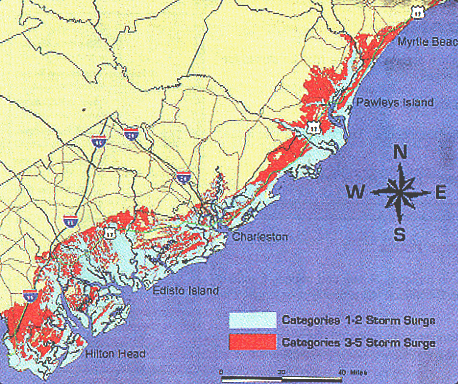
Areas of Vulnerability: “The areas of vulnerability depicted on the map above indicate areas where people may be ordered to evacuate due to tidal surge hazards. If you do not live in the areas indicated below, you may still be vulnerable to flooding and high winds” [F2].
|


.jpg/800px-Arthur_Ravenel_Bridge_(from_water).jpg)
Comments (6)
Bryan Guarente said
at 9:16 pm on Apr 16, 2008
I have fixed your exclamation point problem from an HTML perspective, but cannot find a reason that they were put in there. You should track the changes back to their originator and see if they can tell you anything about the changes they made to the wiki during that time period. You could also just compare the different wiki entries in the history function on the bottom left of the page.
It is possible to revert to an older version of the website if you would like through the history function in the bottom left corner of every page. Just be careful not to remove a newer page. It will prompt you if you are about to do such a thing, so read any prompts that pop-up.
It is understood that the WYSIWYG editor does cause problems. If you have any ability to use the HTML or Source editor, it is highly recommended that you do so.
kfahy2@... said
at 11:10 pm on Apr 16, 2008
is there a reason that our stuff is still all switched around on the page... like things added where there not supposed too.....
apetruz2@... said
at 11:17 pm on Apr 16, 2008
ive been tryin to figure it out for about an hour. ive tried fixing it but everytime i hit save it doenst work and goes back to this.
kfahy2@... said
at 11:22 pm on Apr 16, 2008
so now what.... what do we do??? i think we need to talk to eric about this in class tomarrow.
apetruz2@... said
at 11:26 pm on Apr 16, 2008
i think we can fix it tomorrow. i think that maybe the site is just having some problems. There is a way to view the page for everytime its been saved i think. so once the site is working right again we should be able to go back to what it was before it started gettin all screwed up.
kfahy2@... said
at 11:31 pm on Apr 16, 2008
ok, i just emailed eric and told him what was going on so hopefully we can get this fixed and still stay on schedule! Dont worry about it to much.. i think that we will be able to get someone who knows how to fix it tomarrow!
You don't have permission to comment on this page.